温馨提示:需求数量不同,价格不同。请联系我们,确认当前的报价!
GAEA在Global范围内开发和分发地球科学和工程应用。我们的目标是成为地球科学家和工程师集成软件解决方案的提供商,GAEA的软件已被很多的公司用于收集、存储和可视化地下数据超过25年。GAEA拥有各种各样的人员;例如工程师、地质学家和地球物理学家在使用我们的软件。
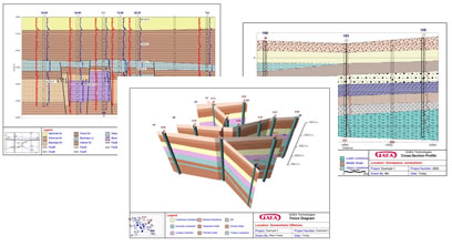
GaeaSynergy的WinFence横截面扩展模块用于访问和绘制钻井/油井数据。各种各样的钻井/油井数据可以绘制在横截面上;包括岩性符号、样本符号、岩心记录、井图、图表和地球物理记录。可以选择让程序使用内置的人工智能(AI)自动生成横截面。当确定如何连接钻孔、井和交叉截面之间的地层时,该程序会查看地层的岩性、厚度和产状的相似性。这种方法适用于大多数地质情况;地质复杂或有断层的地方除外。一种不一样的捕捉方法可用于添加层、蚀变带、侵入体和透镜体边界。这种方法可以将一个层的边界固定到另一个层的边界。边界可以部分绘制,部分捕捉。捕捉的边界可以包括一个或多个不同的层。除了捕捉之外,还可以将地层边界指定给上面或下面的地层。创建横截面后,地层边界可用于创建等值线图。此外,横截面可以作为栅栏图在3D中显示。
以下是WinFence的一些功能列表:
与钻孔或井相关联的EDMS样本和浓度数据可以显示在钻孔/井的位置处的横截面上。
剖面中的地层可以由程序内置的智能自动生成。
栅栏图可以三维方式生成、显示和打印。
在横截面上可以画出多个水位。可以使用存储在WinLoG中的水位自动绘制水位。
等值线图中的网格节点显示在横截面上,可用于自动调整地层边界。
地层边界可用于在扩展等高线模块中创建等高线图。
通过与钻孔/钻井模块更紧密的连接,横截面地层的自动创建得到了改进。
横截面可以包含在项目的页面布局中,可以单独显示,也可以作为剪辑的一部分显示。
横截面路径线可以是直的或弯曲的。
相交的横截面可以显示在横截面上。
自动生成新横截面时,可以使用相交横截面。
横截面可以使用在钻孔/井延伸模块中输入的数据来显示岩性、图形、地球物理日志、样本和井眼位置的井细节。
钻孔/井延伸模块中的地层被自动添加到横截面中。
横截面可以包含无限数量的层、透镜和侵入体。
地层边界可以用直线连接,也可以用曲线拟合。
边界可以捕捉到其他图层或侵入体。
定义地层边界的点可以用图形编辑和删除。
横截面的水平和垂直比例可以由程序指定或自动拟合。
【英文介绍】
GAEA develops and distributes geoscience and engineering applications worldwide. GAEA's software has been used for over 25 years by companies and organizations around the world to collect, store and visualize sub-surface data.Our goal is to be the leading provider of integrated software solutions to geoscientists and engineers.GAEA has more than 3000 firms and organizations in more than 120 countries. A wide variety of professionals; such as engineers, geologists, and geophysicists use our software on a global basis.
The WinFence cross-section extension module of GaeaSynergy can be used to quickly create detailed full color cross-sections. A wide variety of strata can be used to create cross-sections. Depending on the industry, types of strata that can be used include layers, faults, lenses, intrusions, and alteration zones (mineralization, contamination, hydrocarbons, shear strength). Very detailed and complicated stratigraphy can be represented and easily drawn. Each industry version of this module has been specifically designed with data types and strata tailored to that industry.This modulecan be used to access and plot the boring/well data. A wide variety of boring/well data can be plotted on the cross-sections; including lithologic symbols, sample symbols, core logs, well diagrams, graphs, and geophysical logs.There is the option to have the program automatically generate the cross-section using artificial intelligence (AI) built-into the program. When determining how to connect the strata between boreholes, wells, and intersecting cross-sections the program looks at the similarities in the lithologies, thicknesses, and occurrence of the strata. This methodology works well with most geologies; except, where the geologyis very complicatedor there are faults.A unique snapping approach can be used to add layer, alteration zone, intrusion, and lense boundaries. This approach allows the boundary of one strata to be fixed to the boundary of another strata. Making the input of strata boundariesquick and accurate. Boundaries can be partially drawn and partially snapped. Snapped boundaries can include one or more different strata. In addition to snapping, strata boundaries can be assigned to the strata above or below.After the cross-section has been created, the strata boundaries can be used to create contour maps. In addition, the cross-sections can be displayed in 3D as fence diagrams.